As a plane soars over the high desert of southern Peru, the dull pale sameness of the rocks and sand organize and change form. Distinct white lines gradually evolve from tan and rust-red. Strips of white crisscross a desert so dry that it rains less than an inch every year. The landscape changes as lines take shape to form simple geometric designs: trapezoids, straight lines, rectangles, triangles, and swirls. Some of the swirls and zigzags start to form more distinct shapes: a hummingbird, a spider, a monkey.

These are the renowned Nasca lines—subject of mystery for over 80 years. How were they formed? What purpose could they have served? Were aliens involved?
The Nazca Lines /ˈnæzkə/ are a series of ancient geoglyphs located in the Nazca Desert in southern Peru. They were designated as a UNESCO World Heritage Site in 1994. The high, arid plateau stretches more than 80 kilometres (50 mi) between the towns of Nazca and Palpa on the Pampas de Jumana about 400 km south of Lima. Although some local geoglyphs resemble Paracas motifs, scholars believe the Nazca Lines were created by the Nazca culture between 400 and 650 AD.[1] The hundreds of individual figures range in complexity from simple lines to stylized hummingbirds, spiders, monkeys, fish, sharks, orcas, and lizards.
The plain, crisscrossed, by these giant lines with many forming rectangles, has a striking resemblance to a modern airport. The Swiss writer, Erich von Daniken, even suggested they had been built for the convenience of ancient visitors from space to land their ships. As tempting as it might be to subscribe to this theory, the desert floor at Nazca is soft earth and loose stone, not tarmac, and would not support the landing wheels of either an aircraft or a flying saucer.
So why are the lines there? The American explorer Paul Kosok, who made his first visit to Nazca in the 1940s, suggested that the lines were astronomically significant and that the plain acted as a giant observatory. He called them "the largest astronomy book in the world." Gerald Hawkins, an American astronomer, tested this theory in 1968 by feeding the position of a sample of lines into a computer and having a program calculate how many lines coincided with an important astronomical event. Hawkins showed the number of lines that were astronomically significant were only about the same number that would be the result of pure chance. This makes it seem unlikely Nazca is an observatory.
Perhaps the best theory for the lines and symbols belongs to Tony Morrison, the English explorer. By researching the old folk ways of the people of the Andes mountains, Morrison discovered a tradition of wayside shrines linked by straight pathways. The faithful would move from shrine to shrine praying and meditating. Often the shrine was as simple as a small pile of stones. Morrison suggests that the lines at Nazca were similar in purpose and on a vast scale. The symbols may have also served as special enclosures for religious ceremonies.
History
Contrary to the popular belief that the lines and figures can only be seen with the aid of flight, they are visible from atop the surrounding foothills. The first mention of the Nazca lines in print was by Pedro Cieza de León in his book of 1553, where he mistook them for trail markers. Interest in them lapsed until the Peruvian archaeologist Toribio Mejia Xesspe spotted them while he was hiking through the foothills in 1927. He discussed them at a conference in Lima, Peru in 1939, although it must be added that although some of the figures can be worked out from the surrounding foothills the full designs cannot be truly appreciated unless viewed from the sky.
Paul Kosok, a historian from Long Island University, is credited as the first scholar to seriously study the Nazca Lines. In the country in 1940-41 to study ancient irrigation systems, he flew over the lines and realized that one was in the shape of a bird. Another chance helped him see how lines converged at the winter solstice in the Southern Hemisphere. He began to study how the lines might have been created, as well as to try to determine their purpose. He was joined by Maria Reiche, a German mathematician and archaeologist to help figure out the purpose of the Nazca Lines. They proposed one of the earliest reasons for the existence of the figures: to be markers on the horizon to show where the sun and other celestial bodies rose. Archaeologists, historians and mathematicians have all struggled to determine the purpose of the lines.
Determining how they were made has been easier than figuring why they were made. Scholars have theorized the Nazca people could have used simple tools and surveying equipment to construct the lines. Archaeological surveys have found wooden stakes in the ground at the end of some lines, which support this theory. One such stake was carbon-dated and was the basis for establishing the age of the design complex. The scholar Joe Nickell of the University of Kentucky has reproduced the figures by using tools and technology available to the Nazca people. The National Geographic called his work "remarkable in its exactness" when compared to the actual lines. With careful planning and simple technologies, a small team of people could recreate even the largest figures within days, without any aerial assistance.
On the ground, most of the lines are formed by a shallow trench with a depth of between 10 cm (3.9 in) and 15 cm (5.9 in). Such trenches were made by removing the reddish-brown iron oxide-coated pebbles that cover the surface of the Nazca desert. When this gravel is removed the light-colored clay earth which is exposed in the bottom of the trench produces lines which contrast sharply in color and tone with the surrounding land surface. This sublayer contains high amounts of lime which, with the morning mist, hardens to form a protective layer that shields the lines from winds, thereby preventing erosion.
The Nazca "drew" several hundred simple but huge curvilinear animal and human figures by this technique. In total, the earthwork project is huge and complex: the area encompassing the lines is nearly 500 square kilometres (190 sq mi), and the largest figures can span nearly 270 metres (890 ft). Some of the measurements for the figures include that the Hummingbird is 93 meters (310 ft) long, the Condor is 134 meters (440 ft), the Monkey is 93 meters (310 ft) by 58 meters (190 ft), and the Spider is 47 meters (150 ft). The extremely dry, windless, and constant climate of the Nazca region has preserved the lines well. The Nazca desert is one of the driest on Earth and maintains a temperature around 25 °C (77 °F) all year round. The lack of wind has helped keep the lines uncovered and visible to the present day.
The discovery of two new small figures was announced in early 2011 by a Japanese team from Yamagata University. One of these resembles a human head and is dated to the early period of Nazca culture or earlier and the other, undated, an animal. In March 2012 the university announced that a new research center would be opened at the site in September 2012 to study the area for the next 15 years.The team has been doing field work there since 2006 when it found about 100 new geoglyphs.
In 2013, it was reported machinery used in a limestone quarry had destroyed a small section of a line, and caused damage to another.

Theories-
Kosok was followed by the German Maria Reiche who became known as the Lady of the Lines. Reiche studied the lines for 40 years and fought unyieldingly for her theories on the lines’ astronomical and calendrical purpose (she received a National Geographic grant in 1974 for her work). Reiche battled single-handedly to protect the site; she even lived in a small house near the desert so she could personally protect the lines from reckless visitors.
The Kosok-Reiche astronomy theories held true until the 1970s when a group of American researchers arrived in Peru to study the glyphs. This new wave of research started to poke holes in the archeo-astronomy view of the lines (not to mention the radical theories in the ‘60s relating to aliens and ancient astronauts).
Johan Reinhard, a National Geographic Explorer-in-Residence, brought a multidisciplinary approach to the analysis of the lines, “Look at the large ecological system, what’s around Nasca, where were the Nasca people located.” In a region that receives only about 20 minutes of rain per year, water was clearly an important factor.
"It seems likely that most of the lines did not point at anything on the geographical or celestial horizon, but rather led to places where rituals were performed to obtain water and fertility of crops," wrote Reinhard in his book The Nasca Lines: A New Perspective on their Origin and Meanings.
Anthony Aveni, a former National Geographic grantee, agrees, "Our discoveries clearly showed that the straight lines and trapezoids are related to water…but not used to find water, but rather used in connection with rituals."
"The trapezoids are big wide spaces where people can come in and out," says Aveni. "The rituals were likely involved with the ancient need to propitiate or pay a debt to the gods…probably to plead for water."
Reinhard points out that spiral designs and themes have also been found at other ancient Peruvian sites. Animal symbolism is common throughout the Andes and are found in the biomorphs drawn upon the Nasca plain: spiders are believed to be a sign of rain, hummingbirds are associated with fertility, and monkeys are found in the Amazon—an area with an abundance of water.
"No single evaluation proves a theory about the lines, but the combination of archeology, ethnohistory, and anthropology builds a solid case," says Reinhard. Add new technological research to the mix, and there’s no doubt that the world’s understanding of the Nasca lines will continue to evolve.
Related to Water?
Recently two researchers, David Johnson and Steve Mabee, have advanced a theory that the geoglyphs may be related to water. The Nazca plain is one of the driest places on Earth, getting less than one inch of rain a year. Johnson, while looking for sources of water in the region, noticed that ancient aqueducts, called puquios, seemed to be connected with some of the lines. Johnson thinks that the shapes may be a giant map of the underground water sources traced on the land. Mabee is working to gather evidence that might confirm this theory.
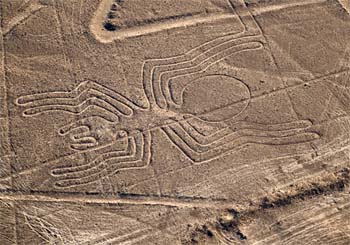
This figure appears to be a giant spider. (© Jarnogz & Dreamstime.com)
|
Other scientists are more skeptical, but admit that in a region where finding water was vital to survival, there might well be some connection between the ceremonial purpose of the lines and water. Johan Reinhard, a cultural anthropologist with the National Geographic Society, found that villagers in Bolivia walk along a straight pathway to shrines while praying and dancing for rain. Something similar may have been done at the ancient Nazca lines.
Human Sacrifice
A recently discovered headless body suggests that human sacrifice was used by the Nazca people in religion ceremonies. "Human sacrifice and decapitation were part of powerful rituals that would have allayed fears by invoking the ancestors to ensure fertility and the continuation of Nasca society," wrote Christina Conlee of Texas State University in an article in Current Anthropology. "The decapitation of the La Tiza individual appears to have been part of a ritual associated with ensuring agricultural fertility and the continuation of life and rebirth of the community." The body is one of eight found in the Nazca area, buried seated with no head. A ceramic jar painted with an image of a head was found next to the remains. The head on the jar has a tree with eyes growing out of it, making it seem likely that the sacrifice was part of a fertility ceremony.
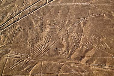
A giant bird biomorph on the Nasca desert plain. (© Jarnogz & Dreamstime.com)
|
What was done with the heads of the victims? The Nazca were known to collect "Trophy Heads." The Nazca removed the brain and soft tissue from the skulls, sewed the lips closed with cactus spines and drilled a hole through the forehead to accommodate a loop of woven rope. The heads were then hung on the ropes for display. Originally these were considered to be war trophies collected from distant tribes, but recent DNA analysis shows that the heads came from the Nazca population itself, suggesting that the motive was religious in nature.
Other South American Lines and Figures
The lines at Nazca aren't the only landscape figures South America boasts. About 850 miles south of the plain is the largest human figure in the world laid out upon the side of Solitary Mountain in Chile. The Giant of Atacama stands 393 feet high and is surrounded by lines similar to those at Nazca.
Along the Pacific Coast in the foothills of the Andes Mountains is etched a figure resembling a giant candelabrum. Further south, Sierra Pintada, which means "the painted mountain" in Spanish, is covered with vast pictures including spirals, circles, warriors and a condor. Archaeologists speculate that these figures, clearly visible from the ground, served as guideposts for Inca traders.
"The geometric ones could indicate the flow of water or be connected to rituals to summon water. The spiders, birds, and plants could be fertility symbols. Other possible explanations include irrigation schemes or giant astronomical calendars."
No comments:
Post a Comment